

I’ll be writing weekly weather updates for MaxSled this year. In the article, I will give you updates on snow depths, current conditions, and a forecast for the next week. Hopefully, we will be receiving plenty of snow this year!
Over Look on this Season So Far
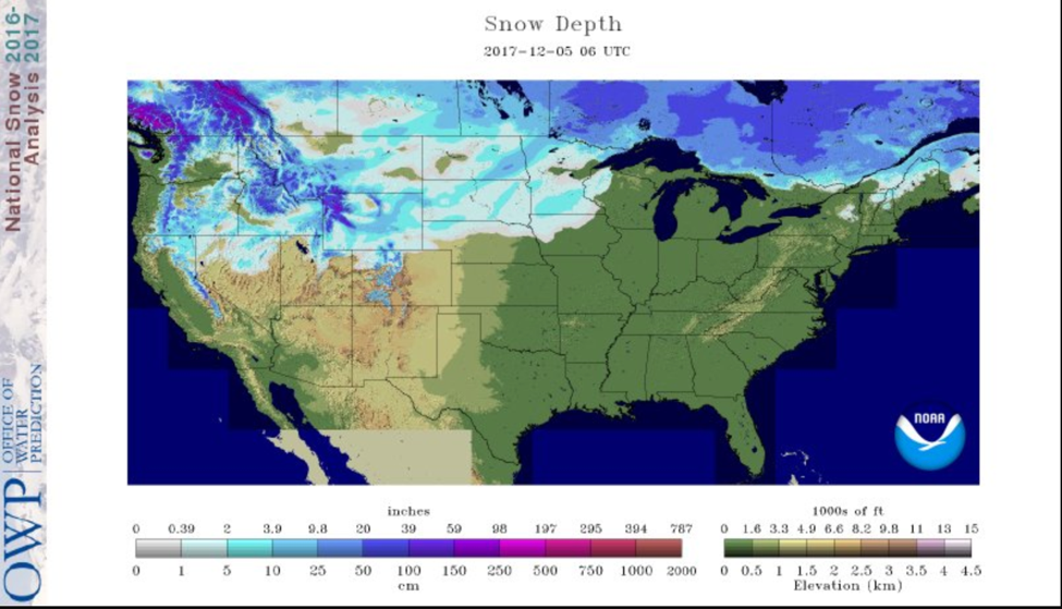
Modeled Snow Depths for the Continental U.S. (12/5/2017) Source National Operational Hydrologic Remote Sensing Center.
We started the season out strong with snow in early November over the Northern Plains. Unfortunately, a warm latter half of the month melted most of the snow and we find ourselves starting back at square one! The above figure shows the current snow depths over the lower 48 as of December 5th. The Midwest has a fresh new layer of snow with around 1-4 inches. As well as Montana, Idaho, Washington, and Oregon have some snow cover with around 1-4 inches. In higher elevation, the snow depths are developing with around 20 inches, and this is where most folks have been getting riding in so far.
Compared to the last year, things are looking up. Fortunately, we are in a weak La Nina this year; which means below average temperatures in the Eastern Central Pacific Ocean. This is good news for us, La Nina typically brings us below-normal temperature and above-average precipitation in the North.
Current Conditions
As you may know, most trails are not able to be ridden right now. That said, a system early this week associated dropped a half foot of snow from ND into MN, putting us back in winter mode. The expansion of cold air will also be welcome out east. This will bring prime conditions for lake effect snow in upstate NY. The season has just begun and with more hopeful snowfalls coming soon, December is looking up.
Weekly Forecast
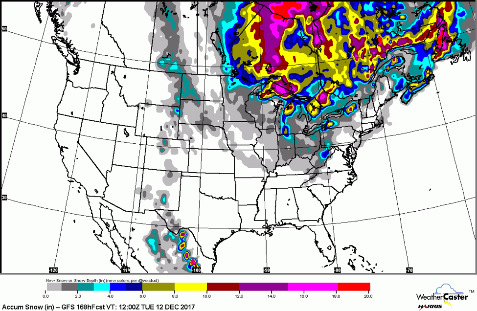
12/5/2017 GFS Model Forecast for snowfall accumulation for 7 days out. Source Harris WeatherCaster™ .
The latest forecasted snowfall from the US weather model clearly shows the biggest story for the upcoming week is lake effect snow, with a number of maximums on the eastern side of the Great Lakes. This may finally give us the base needed to get trails in these areas into groomable conditions! However, this is just one model and exact positioning and amounts are subject to change.
Unfortunately, in the west, the rest of this week looks pretty dry due to a large ridge allowing the jet stream to avoid this area. Hopefully, that will change over the course of the next week so I’ll have more exciting news for our western mountain riders.
The season is just beginning, so keep your hopes high for more snow and cool temperatures to keep the snow around. La Nina gives us a more optimistic look for the upcoming season! For those of you with snow, have fun this weekend. Stay safe and happy sledding!
About MaxWeather: We have partnered with the University of North Dakota Dept. of Atmospheric Sciences to give students a practical internship experience, providing weather forecasts for our readers. We will bring you a weekly, student-developed weather update throughout the snowmobiling season.
About the UND program: Located in the heart of cross-country racing territory, the University of North Dakota Dept. of Atmospheric Sciences provides high quality undergraduate and graduate education. Embedded in an environment of significant research and discovery, students have the opportunity to participate in hands-on forecasting and research activities. http://atmos.und.edu/