

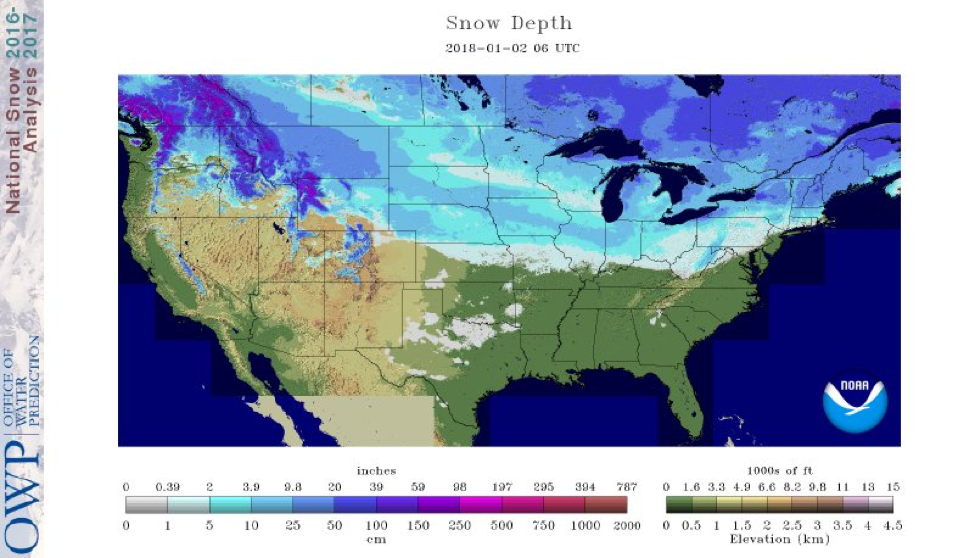
Updated Modeled Snow Depth for the Continental U.S. on 01/02/2017. Source: NOHRSC
I hope everyone had a nice cold New Years! Luckily, the cold arctic air allowed for more snow over the week. Once again, we have increased snow depths throughout the northern tier of the US. A storm system passed through Montana and moved eastward through South Dakota last weekend and now most parts of South Dakota have a solid snow base. Montana also received more snow and currently has a snow depth greater than 10 inches over most of the state.
Trail Conditions
The cooler temperatures allowed the snow to stay and water to freeze over the week therefore riding conditions are looking up. Northeast state trails are almost 80% to fully open. Throughout the Midwest, Minnesota, Michigan, and Wisconsin, most northern trails are open, yet many of the southern trails remain closed. With a new layer of snow in Montana, most trails are open. As always be aware of avalanche conditions in high elevations and ice depths over bodies of water.
Forecast
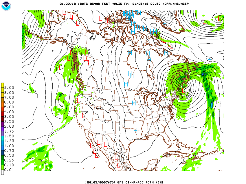
GFS model forecast for Thursday, 1/02/2018 00UTC. Source: NOAA
Cold temperatures should remain this week for most of us. Warm temperatures will start in the West then move eastward with the Midwest seeing warmer temperatures this weekend. The Northeast should see the temperatures warming up next week.
Energy off of the west coast will bring an active weather pattern to the Northwest then move eastward. This will bring rain to the west-coastal states with snow in higher elevations. As the system moves eastward, hopefully, the Northern Midwest will be receiving snow with warmer temperatures this weekend. Then the temperatures will drop cold once again this time next week.
The arctic air will stay around this weekend for the Northeast. A Canadian maritime trough and an east-central U.S. high pressure will create strong winds over New England at the end of this week. The trough will bring significant precipitation around Thursday. Inland and high elevation should receive a new layer of snow. Beware of cold wind chills and blowing snow in the New England area this weekend. The GFS model shows the low-pressure system on Thursday night with a strong gradient and precipitation in New England. However, this is only one model run. Hopefully by Monday, warmer temperatures will move into the air. The lake effect will lose energy with warmer temperatures.
As always safe sledding!
-Megan
About MaxWeather: We have partnered with the University of North Dakota Dept. of Atmospheric Sciences to give students a practical internship experience, providing weather forecasts for our readers. We will bring you a weekly, student-developed weather update throughout the snowmobiling season.
About the UND program: Located in the heart of cross-country racing territory, the University of North Dakota Dept. of Atmospheric Sciences provides high quality undergraduate and graduate education. Embedded in an environment of significant research and discovery, students have the opportunity to participate in hands-on forecasting and research activities. http://atmos.und.edu/