

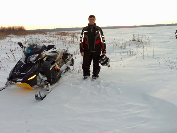
Mark Bresnahan is a senior at the University of North Dakota College of Aerospace Sciences majoring in meteorology and lifelong sledder.
My name is Mark Bresnahan, and snowmobiling has been my lifelong passion. Starting at a young age on a 1981 Kitty Cat and progressing to a recently purchased 2012 Ski-Doo GSX, I’ve ridden my whole life. Whether it’s driving down beautifully groomed trails or carving the deep powder in the swamps of northern Minnesota, I enjoy all types of riding.
I’m originally from Bloomington, Minnesota but most of my riding is done around the Walker-Longville-Grand Rapids area in the northern part of the state.
Currently, I’m a senior at the University of North Dakota College of Aerospace Sciences majoring in meteorology, and I’ll be writing weekly weather updates for MaxSled with the hopes of tracking plenty of snow (and cold) well into March and April.
Trail Conditions
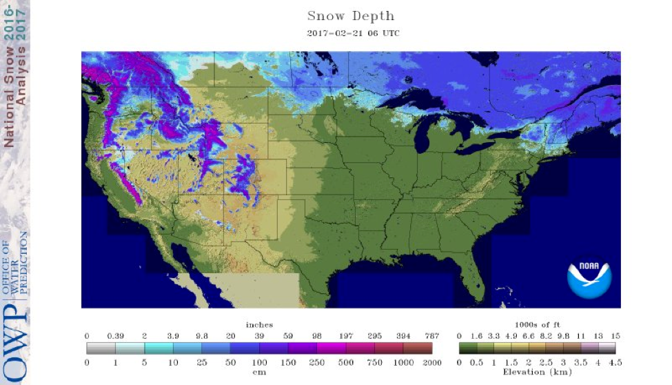
Modeled Snow Depth for the Continental U.S. (2/21/17). Source: National Operational Hydrologic Remote Sensing Center (NOHRSC)Except for our friends in the far northeastern U.S., the rest of the country’s snow pack has unfortunately taken quite the hit over the last week and a half due to a persistent upper level ridge over the central continental United States (CONUS) that brought well above average temperatures to North Dakota, Minnesota, Wisconsin, and Michigan. To make matters worse, moderate rain fell on Monday (2/20) depleting the snow pack even more across northern Minnesota, northeastern Wisconsin, and the UP of Michigan.
Even with the significant melting, far northern North Dakota, the arrowhead of Minnesota, and the UP of Michigan all had pretty decent trails until the rain came through. I haven’t seen any updated trail reports yet, but with upwards of half an inch of rain on top of the previous warmth over these areas, those trails have to be wearing pretty thin. Here are a few state trail report sites for you to check out:
Maine Trail Conditions | Michigan Trail Conditions | Minnesota Trail Conditions | New Hampshire Trail Conditions | New York Trail Conditions | North Dakota Trail Conditions | Wisconsin Trail Conditions | Vermont Trail Conditions
Weather Forecast Models
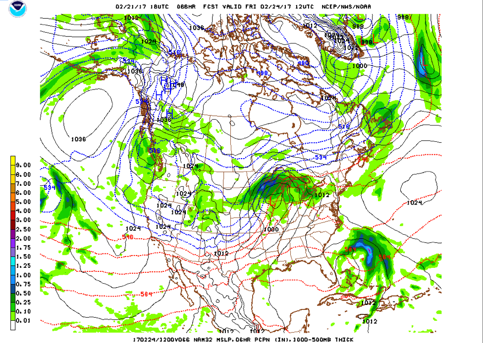
Luckily for us, it looks like the weather pattern across the northern U.S. is going to change by the end of the week. This will be triggered by a potent winter storm that will occur across the upper Midwest from Thursday-Saturday. Right now, the main impact area looks to be from central Nebraska to the Twin Cities area southeastward and northeast into Wisconsin and the UP of Michigan.

2/21/17 6PM GFS Model Run
Source: National Center for Environmental Protection (NCEP)
Here is the storm position midnight Friday morning (2/24). This track favors heavy snow along a line from Sioux City-Rochester-Eau Claire. Any change in the track of the low pressure system (currently located over northwestern Missouri) will shift the heavy snow line. Riders currently being shut out of this system in northern Minnesota and northeastern North Dakota should hope for a northerly shift (ideal track of the low should be over the Twin Cities area). Unfortunately, with these types of late winter systems, there is a rain/snow line that will be shutting out hopefuls of some much needed snow. Right now, this line looks to be setting up from extreme southeastern Minnesota into central Wisconsin, with all snow to the north and west and rain changing to snow along and south of that line.
2/21/17 6PM NAM Model Run
Source: National Center for Environmental Protection (NCEP)
Here is a different model at the same time. The NAM model is a little quicker with the system and has the center of the low pressure system a little farther to the souteast. This displays one of the issues meteorologists have when nailing down snow totals. The more southerly solution will in turn shift the heaviest snow bands to the south and east, but if the system follows closer to the GFS, the band will be closer to the Twin Cities northeastward.
Snow Totals
So just how much snow are we expecting? Wherever the heaviest snow band sets up, we can expect totals of 6+ inches in that area, with lesser amounts on either side. There will be an extremely sharp cutoff on snow totals on the northwest side of this system.
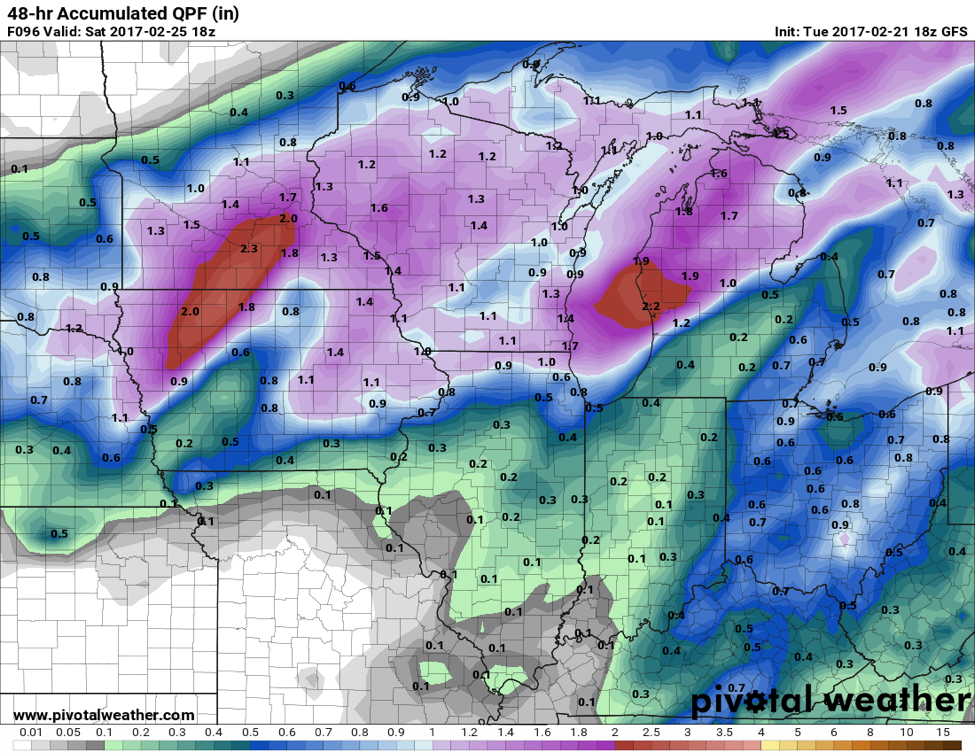
The latest GFS model looks promising for precipitation across the upper Midwest. Source: Pivotal Weather
Here is the latest GFS model run for accumulated precipitation from 6PM Thursday to 6PM Saturday. These aren’t snow totals, but inches of liquid precipitation. It’s safe to assume a snow liquid ratio of 10:1. Every inch of precipitation will be approximately 10 inches of snow. Some of the precipitation early on, especially farther south, will begin as a mixed precipitation or just plain rain. This will cut down on snow totals, and the time when the precipitation changes to all snow across the area will greatly affect the final snow totals. This GFS model run looks pretty generous on precipitation. I don’t think we’ll be seeing liquid precipitation totals this high, but a wide swath of at least 6+ inches of snow is very likely in the heaviest band, which will be located from southern Minnesota into west-central Wisconsin.
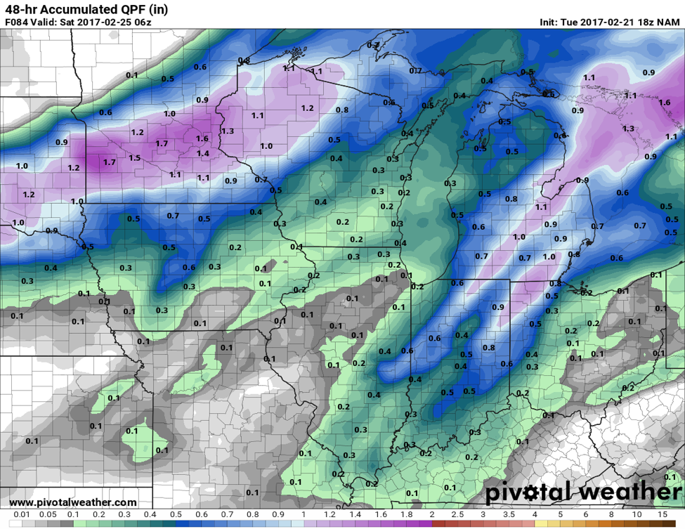
The NAM run anticipates the heaviest snow band setting up a little farther north. Source: Pivotal Weather
The NAM run looks much more reasonable for accumulated precipitation. It also has the heaviest snow band setting up a little farther north, even though it has a more southerly track. This is another good example of the headaches these models can give us. Keep in mind that for both model solutions, some of the precipitation could begin as a mix, which is why we unfortunately aren’t predicting 15+ inch snow amounts.
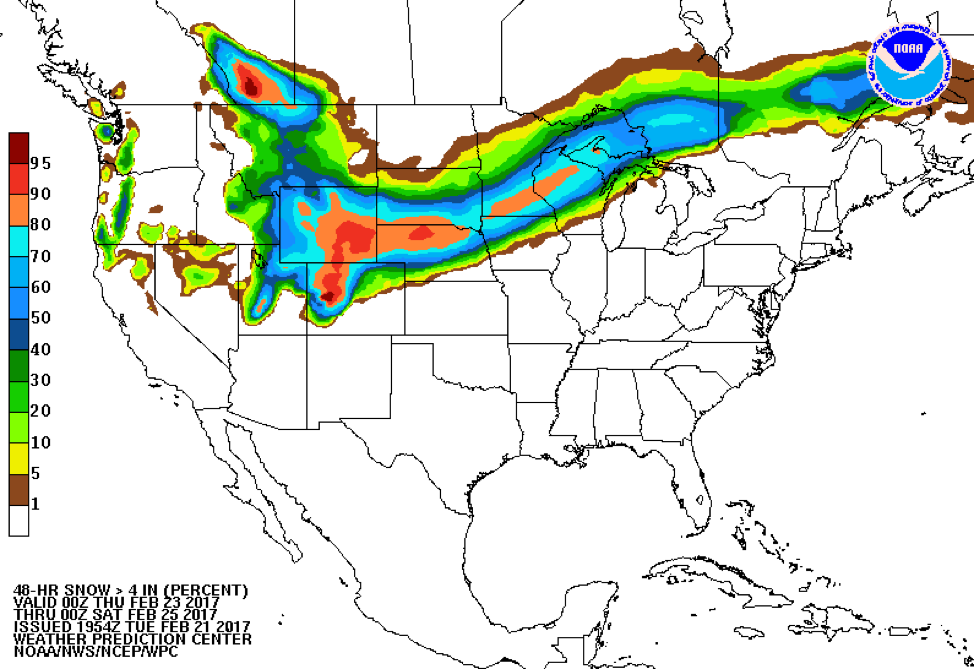
Probability map of at least 4 inches of snowfall between Wednesday and Friday evening. Source: Weather Prediction Center
Finally, here are the probabilities of at least 4 inches of snow falling between 6PM Wednesday and 6PM Friday.
Bottom line, winter is definitely back for portions of the upper Midwest – especially in southern Minnesota and western and central Wisconsin. This storm will generate enough snow to get the trails covered, and for you to get out and have some fun. Happy riding!
About MaxWeather: We have partnered with the University of North Dakota Dept. of Atmospheric Sciences to give students a practical internship experience, providing weather forecasts for our readers. We will bring you a weekly, student-developed weather update throughout the snowmobiling season.
About the UND program: Located in the heart of cross-country racing territory, the University of North Dakota Dept. of Atmospheric Sciences provides high quality undergraduate and graduate education. Embedded in an environment of significant research and discovery, students have the opportunity to participate in hands-on forecasting and research activities. http://atmos.und.edu/